


")


")
")


 Website")


: Ghana’s Iconic Handwoven Smock, Cultural Identity & Why It’s Trending Today")


")
, Africa Cup of Nations 2023 Final Hіghlіghts, William Troost-Ekong goal, Simon Adingra’s cross, Franck Kessie goal & Sebastien Haller goal (Video)")
(4-2 Penalties), Africa Cup Nation, AFCON 2023 All Penalties Goals (Video)")
 score, result, highlights: FIFA World Cup 2022 Third Place (Video)")
 score, result, highlights: Messi World Cup magic and Alvarez double books final spot (Video)")
 FIFA World Cup 2022 score, highlights, result as Hernandez and Kolo Muani fire Les Bleus to final (Video)")
")
 (3-0) [Video].")


")
")
")
")
")
: Spain Crowned FIFA World Cup 2026 Champions After Dominant Final Performance, Ferran TORRES Goal (Video)")
 & France vs Spain (0-2): FIFA World Cup 2026 Semi-Finals Set Up a Blockbuster Finale (Video)")

: Spain Edge Belgium in a Dramatic 2026 FIFA World Cup Quarter-final (Video)")


")
")


")


")
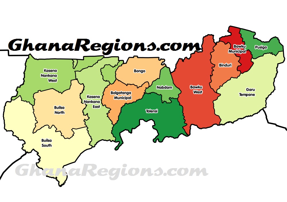
Upper East Region, in the north-eastern corner of the country, is the gateway to Ghana from Burkina Faso and Togo.
The Upper East Region is an excellent tourist destination in its own right, offering visitors an exciting introduction to Ghana.
The regional capital, Bolgatanga- locally known as Bolga- has always been a meeting point for traders from Mali and Burkina Faso traveling south to Temale and southern Ghana. Other major towns in the region include Navrongo, Paga, Bawku and Zebilla.
The Upper East Region is located in north Ghana and is the third smallest of the 16 administrative regions in Ghana. It occupies a total land surface of 8,842 square kilometers or 2.7 per cent of the total land area of Ghana.
Geography – Location and size
The Upper East region is located in the north-eastern corner of Ghana and bordered by Burkina Faso to the north and Togo to the east. It lies between longitude 0° and 1° West, and latitudes 10° 30′N and 11°N.
The region shares boundaries with Burkina Faso to the north, Togo to the east, Upper West Region to the west, and the Northern Region to the south. The Upper East region is divided into 15 districts, each headed by a district chief executive.
Demographics – Population
The center of population of the Upper East Region is located in its capital of Bolgatanga.
The population is primarily rural (79%) and scattered in dispersed settlements. The rural population was 87.1 percent in 1984 and 84.3% in 2000.
There was, thus, a 2.8 percentage point reduction in the rural share of the population between 1984 and 2000 and a further 5.3 percent reduction between 2000 and 2010.
With only 21 per cent of the population living in urban areas, the region is the least urbanized in Ghana. In fact, together with Upper West, they are the two regions with a less than 20 per cent urban population.
Ghanaian citizen by birth, childhood or parenthood constitute 92.5 percent of the population of the Upper East region. Naturalized Ghanaian citizen constitute 5.3 percent.
Upper East Region has a total population of 1,301,221 in the 2021 Population and Housing Census.
Transportation
Three national highways – N2, N10, and N11 – and a few Regional highways such as the R113, R114, R116 and R181, serve the region.
The N10 originates from Yemoransa in the Central Region and connects through Kumasi in the Ashanti Region and terminates at Paga in the Upper East Region.
The national capital of Accra is also connected to the region by the N2 which terminates in Kulungugu in the Upper East Region. Both these national routes are connected by the N11 which links the regional capital of Bolgatanga to Bimpiela, also in the region.
Administrative divisions
The political administration of the region is through the local government system. Under this administration system, the region is divided into 15 MMDA’s (made up of 0 Metropolitan, 4 Municipal and 11 Ordinary Assemblies).
Each District, Municipal or Metropolitan Assembly, is administered by a Chief Executive, representing the central government but deriving authority from an Assembly headed by a presiding member elected from among the members themselves.
: Spain Crowned FIFA World Cup 2026 Champions After Dominant Final Performance, Ferran TORRES Goal (Video)")
 & France vs Spain (0-2): FIFA World Cup 2026 Semi-Finals Set Up a Blockbuster Finale (Video)")


