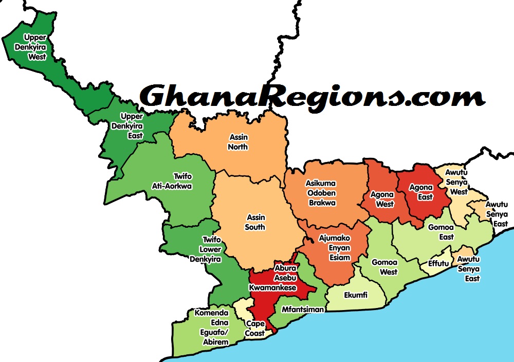
The Central Region is one of Ghana’s sixteen (16) administrative regions. It is bordered by the Ashanti and Eastern regions to the north, Western region to the west, Greater Accra region to the east, and to the south by the Atlantic Ocean.
History and Geography
The Central Region was historically part of the Western Region until 1970 when it was carved out just before the 1970 Population Census. It occupies an area of 9,826 square kilometres or 4.1 per cent of Ghana’s land area, making it the third smallest in area after Greater Accra and Upper East. It shares common boundaries with Western Region on the west, Ashanti and Eastern Regions on the north, and Greater Accra Region on the east. On the south is the 168-kilometre length Atlantic Ocean (Gulf of Guinea) coastline.
The region was the first area in the country to make contact with the Europeans. Its capital, Cape Coast, was also the capital of the Gold Coast until 1877, when the capital was moved to Accra. It was in the castle of Cape Coast that the historic Bond of 1844 was signed between the British and the Fante Confederation.
In all, there are about 32 major festivals in the region. Notable among these are the Aboakyer at Winneba, Fetu at Cape Coast and Bakatue at Elmina.
The region has two Universities – University of Cape Coast and the University of Education, Winneba. The Cape Coast Municipality has excellent educational institutions like Mfantsipim School, St. Augustine’s College, Wesley Girls High School, Adisadel College and Holy Child that have produced some of the prominent citizens in the country.
The region’s population is 1,593,823. The corresponding 1984 population was 1,142,335. This means that the region’s population is growing at a rate of 2.1 per cent per annum. The region is also the second most densely populated in the country, with a population density of 162 persons per square kilometre. Out-migration, which continues to be a problem in the region, is declining gradually with immigrants constituting about a quarter of the population in all the districts. Between 1984- 2000, the region recorded a net out-migration rate of 14.3 per cent compared to that of 15.4 per cent recorded in the period 1970-1984.
Roughly between 20 and 37 per cent of the population in the districts are migrants. Twifo- Hemang-Lower Denkyira has the highest proportion of migrants of (37%) and Ajumako- Enyan-Essiam has the least (20%). Inter-regional migrants are more than intra-regional migrants in three districts, while four other districts receive more intra-regional migrants. In almost all the districts, most of the immigrants come from the Western, Greater Accra, Ashanti, Volta and Eastern Regions. The region is typically rural in nature, though there has been an increase in the urban population from 28 per cent in 1960 to 37.5 per cent in 2000. The most urbanised districts, which are about two-thirds urban, are Cape Coast, Awutu-Efutu-Senya and Agona.
Urban/Rural
The rural/urban classification of localities is population based, with a population size of 5000 or more being urban and less than 5000 being rural, as used in earlier censuses.
Physical Features
The region can be broadly divided into two: the coast, which consists of undulating plains with isolated hills and occasional cliffs characterised by sandy beaches and marsh in certain areas and the hinterland, where the land rises between 250 metres and 300 metres above sea level.
The Region lies within the dry equatorial zone and moist semi-equatorial zone. Annual rainfall ranges from 1,000mm along the coast to about 2000mm in the interior. The wettest months are May-June and September-October while the drier periods occur in December- February and a brief period in August. Mean monthly temperature ranges from 240C in the coolest month (August) to about 300C in the hottest months (March-April).
Vegetation
Along the coast can be found the coastal savannah with grassland and few trees while semideciduous forest predominates the inland areas. Much of the original dense forest vegetation has been cleared for the cultivation of cocoa and oil palm.
Natural Resources
The region is endowed with rich natural resources like: gold, beryl and bauxite in the Upper Denkyira District; petroleum and natural gas at Saltpond; kaolin in the Mfantsiman district; diamond at Nwomaso, Enikokow, Kokoso all in the Asikuma-Odoben-Brakwa District; clay including pigment clay in all the districts; tantalite and columbite at Nyanyano in the Awutu- Efutu-Senya District; quartz, muscovite; and other minerals like mica, granite, feldspar as well as timber in all the forest areas; rich fishing grounds along the coast; forests and rich arable land.
Political and Administrative Structure
The region was created in 1970 and at the time, it consisted of three districts and 18 local authorities. However, in 1988, the existing 18 local authorities were recombined into 12 administrative districts.
Cultural And Social Structure
Nationality
Ghanaians constitute 96.9 per cent of the total population in the Central Region, made up of 92.5 per cent Ghanaians by birth and 4.4 per cent naturalized Ghanaians. There are more naturalized males than females. There has not been much change in the proportion of Ghanaians and non-Africans since 1970.
Ethnicity
The region is predominantly Akan speaking (82.0%), followed by Guan (6.1%) and Ewe (4.8%). The Fante, who are mainly along the coast, are the predominant group among the Akan (56.6% of regional but 69.1% of Akan population). A number of small ethnic groups in the region (Mole Dagbon, Grusi; Gurma and Mande- Busanga), constituting 3.4 per cent of the population of the region, originate from the northern part of Ghana.
Occupation
In both 1984 and 2000, agriculture was the main type of economic activity for both males and females. Agriculture was even more important in 1984 (64.0%) than 2000 (54.8%). This means that an increasing proportion of people in the economically active population is shifting from agriculture to other areas of economic sectors, as urbanization increases and people attain higher education. Sales was the second major economic activity in 1984 while it ranks third in 2000.
Apart from agriculture and sales, a significant proportion are engaged as production and transport equipment operators. There were more people engaged in this activity in 2000 (16.1%) than in 1984 (13.8%). In each of these years, the proportion of males was higher than that of females in this field. Between 1984 and 2000, the proportion engaged in professional and technical jobs increased from 3.9 per cent to 6.4 per cent. As in the case of production, transport and equipment operators, the proportion of males in professional and technical occupation was higher than that of females.
The proportion of those engaged in clerical and related jobs as well as those engaged in services, increased between 1984 and 2000. In both years, the proportion of males was higher than that of females for clerical and related jobs. In the case of services, the proportion of females is higher. While the proportion of females in administrative and managerial occupations increased, that of males declined.




















![Morocco knock out Spain on 3-0 penalties to reach FIFA World Cup 2022 quarter-final, Morocco vs Spain (0-0) (3-0) [Video]. Morocco knock out Spain on 3-0 penalties](https://ghanaregions.com/wp-content/uploads/2022/12/Watch-Morocco-vs-Spain-0-0-and-3-0-penalties-218x150.jpg)


